Scout farms, fields, crop health using imagery, flags, lines and areas.
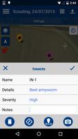
Change the way you use GPS for field mapping and scouting applications in agriculture. Trimble’s Connected Farm™ scout app uses your phone's GPS for mapping field boundaries, marking flags, and entering scouting information for points, lines, and polygon areas. Select from an extensive list of weeds, insects and diseases while entering the severity of a problem, crop condition, and more. Photos can also be captured and integrated with your scouting information.
The Connected Farm Scout app is compatible with the PurePixel™ precision vegetation health solution. PurePixel allows you to analyze the crop health at various stages of the growing season. These vegetation maps can display in the background to help navigate you to struggling areas of the field, saving you precious time with targeted scouting.
The app is flexible to use with any crop such as corn, wheat, soybeans, cotton, rice, vegetables, and more.
All data is sent via the cell or WI-FI connection to Connected Farm (www.connectedfarm.com) where you can view, sort, and print data online. The app is also compatible with Farm Works Software®.
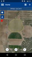
FIELD BOUNDARY MAPPING
• Calculate areas (acres or hectares) and map field boundaries.
• Utilize the offset feature to enter a distance between you and the actual boundary when logging.
• Display background satellite imagery
GENERAL MAPPING
• Switch between logging paths, points, and polygon areas.
• Customize personal notes to various jobs.
• Enter data easily without a keyboard using the built-in pick list.
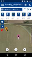
SCOUTING
• Enter scouting attributes for pests, weeds or diseases and log the severity of problems and crop conditions.
• Capture and geo-reference digital images of pests using the phone or tablet’s built-in camera and GPS.
• View PurePixel vegetation health imagery in the background to help with targeted scouting.
• View previously logged scouting data in the background to help understand if areas are improving or not.
NITROGEN RECOMMENDATIONS
• Calculate nitrogen rates by using NDVI (Normalized Difference Vegetation Index) crop readings from the GreenSeeker handheld crop sensor.
• Saves the geo-referenced location of the NDVI point.
DATA MANAGEMENT
• Manages your data by client, farm, and field names.
• Transfer your data to the Connected Farm where you can view, sort, and print your data online.
• Utilize your Connected Farm account to automatically backup your data. Never lose data again.
• Compatible with Farm Works Software.
-----
Note: Continued use of GPS running in the background can dramatically decrease battery life.
If you are bored with playing the vanilla version of Metaphor ReFantazio, you can check out these five mods.
Get free Primogems, Mora, Experience, and more with these November 2024 Genshin Impact codes, 5.1 livestream codes, and find out how to redeem active codes.
Struggling with your submissions for Roblox's The Haunt event in 2024? Check out our guide on using Dress to Impress to create your captures!
Our walkthrough for Dragon Age: The Veilguard with some handy tips and tricks, with guides for puzzles, bosses, companions, equipment, romance, and more!
Looking for some bonus resources in Sea of Conquest: Pirate War? We’ve got you covered with these codes for the latest seafaring freebies.
Which faction should you pick in Dragon Age: The Veilguard?
On our website, you can easily download the latest version of Connected Farm Scout! No registration and SMS required!